CRUISE APPLICATION | SAFETY

To be able to use the preventive maintenance model, please complete the interest form.

To be able to use the preventive maintenance model, please complete the interest form.

To be able to use the preventive maintenance model, please complete the interest form.

Description

Based on the SOLAS (Safety Of Life at Sea) regulation of the IMO (International Maritime Organization), all cruise or passenger ships are required to provide passengers with simple instructions regarding safety and handling of emergency situations. Evacuation information is primarily displayed through static means, specifically safety leaflets, which are posted throughout the ship in cabins and corridor/common area walls.

Given that large passenger ships consist of complex infrastructures with a large number of decks/common spaces, in case of emergency, difficulties may arise in the attempt to find an evacuation route, a situation that is further exacerbated by the large volume of passengers, including the crew. Moreover, the ship's status during an emergency constantly changes, and today's static means and leaflets cannot adequately cover the dynamic evolution of the ship's situation.

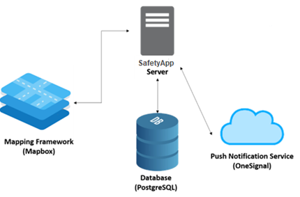
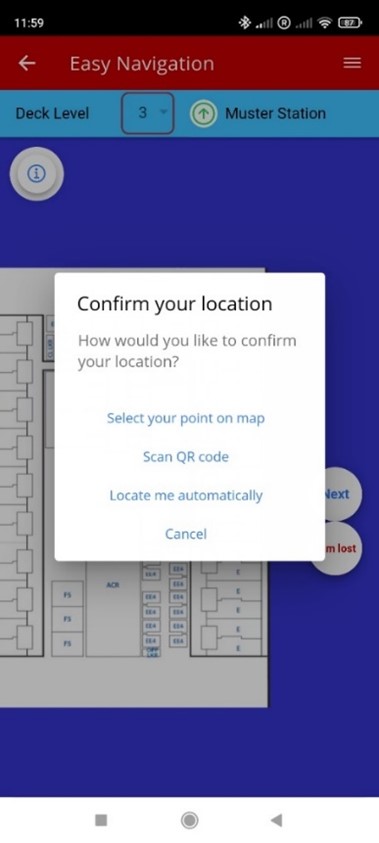
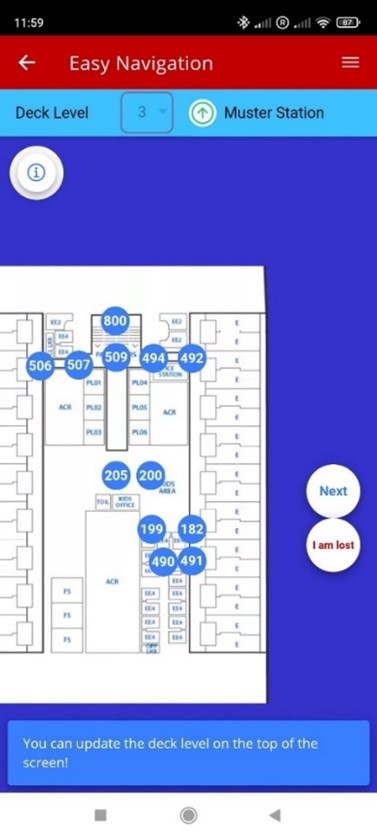
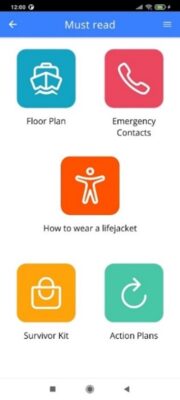
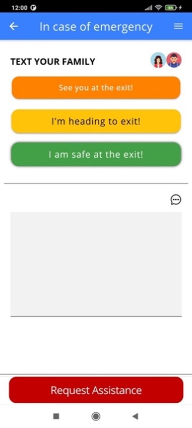
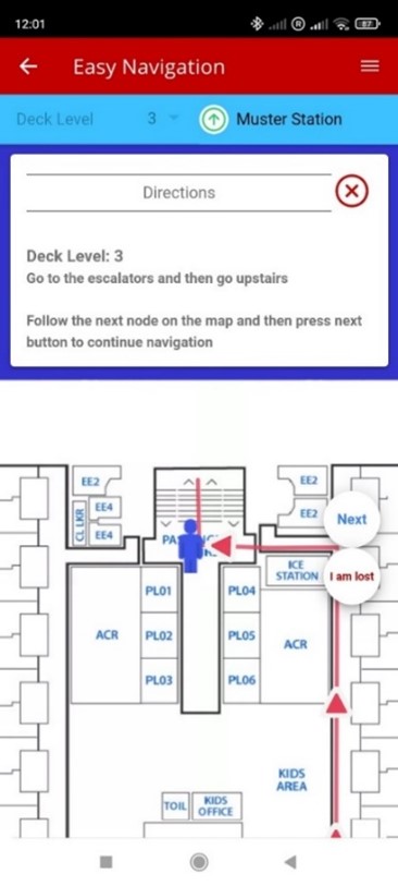
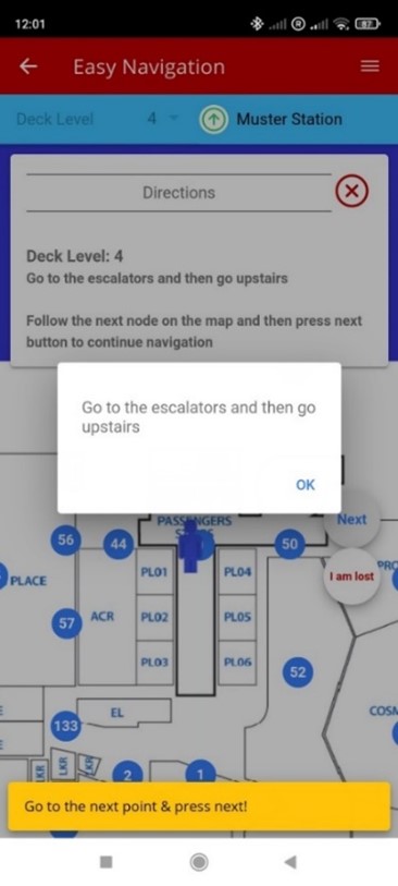
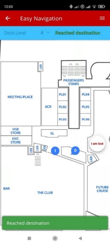
In this context, and to enhance the safety of passenger ships/cruise ships, the Cruise SafetyApp was developed for mobile phones and for use by passengers. The application, in critical situations, supports the evacuation process, offering dynamic instructions for their safe movement to the assembly stations (muster stations), based on their respective position on the ship, while in everyday operating conditions it helps passengers move - navigate on the ship, offering them useful information about points of interest (POIs) and options, choices available to them.

The application will be available to all passengers/smartphone users upon their entry into the ship's area and will be provided at no additional charge.

Solution Category

Mobile Application

Description

The SafetyApp platform is an innovative mobile application that provides dynamic and personalized visual navigation to specified safe exits, gathering stations for each passenger, based on their real-time location, facilitating passenger familiarization with the ship's spaces and safety instructions.

Cutting-edge technologies

Platform development

The application implementation (Front End) was facilitated by an interoperable (cross-platform) development environment (Ionic Framework), which allows the development of applications with a common code base for all smartphones (iOS and Android) - a native application is subsequently produced that is available for the App Stores (Apple, Google respectively). Concurrently, for the development of the platform's data management (Back End), Java (Java Spring Boot framework) was used, while the Database has been developed in PostgreSQL to meet the platform's needs.

Indoor Positioning

For locating passengers (especially in indoor areas) and guiding them within the ship, specialized devices-transmitters (BLE beacons) are used, which use low-energy Bluetooth technology (BLE) for their communication with the passenger's mobile phone and the automatic determination of their position. Beacons can easily be placed in any space, offering interaction capabilities with mobile devices up to 150m away.

Application design

The design of the application followed a modern approach, providing a user-friendly interface, requiring no special knowledge or experience for use by any user. The color palette used is pleasant and relaxing, with the necessary color contrasts, to highlight text and images. The application has the ability to support multilingual content (e.g., GR, EN), depending on the requirements.

Application users

The application is used by ship/cruise passengers as a digital substitute for the safety leaflet in case of emergency/evacuation, but also in their daily life on the ship as a digital assistant ("digital concierge"), informing them about activities, offers, making reservations for shows, navigating them to POIs etc.

Economic Sectors

Tertiary sector

Hosting nature

Cloud infrastructure Local Installation


Platform Architecture Diagram

Application Architecture (Front end)

Application Architecture (Back end)

The interconnection of the SafetyApp platform with an external application (MapBox) allows the storage and display of the ship's maps on the mobile app through a specialized API. Also, the integration of the platform with another external application (oneSignal) provides the ability to push notifications to users in case of a need for the ship's status.

Innovation

The SafetyApp solution, in accordance with safety requirements on passenger ships / cruise ships, offers a comprehensive application to passengers for their support in case of need, but also in their daily life on the ship. The SafetyApp is (at least) a digital substitute for the passenger safety brochure, similar to what is posted in various places on the ship. Passengers can check their position on the ship at any time on the mobile app and use map-based visual navigation to follow the appropriate, safest evacuation route during an evacuation scenario. Throughout the scenario, the application guides the user, point by point to the indicated evacuation exit, while simultaneously providing a visual and written message on the screen.

At the same time, the application and specifically the Back End functions of the application allow a high degree of operational awareness in emergency situations. Specifically, through interaction with the application, passengers participate in information collection, sending & receiving notifications & locating their position inside the ship, thus offering real-time information about what is happening on the ship - "participatory data collection" ("Participatory Sensing" or "Crowd-sourced Awareness").

Also, given that locating the passengers' position is practically impossible inside the ship using GPS, location has been specified and is implemented with three different alternative methods:

  1. Automatic position determination via the developed BLE beacons in common areas
  2. Manual indication on the map of the passenger's position
  3. Semi-automatic location by scanning the QR codes that are posted / printed at points on the ship

Alternative methods of locating and indicating position

Innovative Technologies

ΙοΤ Cloud computing BLE beacons technology

Ωριμότητα λύσης

Based on the Technology Readiness Level (TRL) scale with values from TRL 1 to TRL 9, the Gruise SafetyApp platform is at level TRL 9.

Provided Services

The application includes particularly dynamic content offering:

  • Display of the ship's map (overviews of the ship's spaces), with reference to points of interest (POIs) (e.g., shops, restaurants), as well as information on muster stations in case of evacuation.
  • Display of the user's position on the ship's map and the ability to navigate to points of interest.
  • User update about the situation on the ship through notifications (Push notifications) in case of emergency.
  • Real-time navigation of the user to the nearest muster station via a safe route based on his position and the current situation on the ship.
  • The ability to chat with written messages between groups of people (family members or companions traveling together) so that immediate communication is possible even without 4G/5G mobile phone coverage (through connection with a commercial system, e.g., Oracle Fidelio).
  • The ability of a passenger to request help by selecting a button in the application "Request for help" ("Request assistance") in case he is injured or in danger.
  • Recording of emergency contacts and answering a series of questions to determine the nature of the problem, the ability to communicate with the ship's medical office.
  • Instructions on how to wear your lifejacket.
  • Safety information (survivor kit), which includes a handy guide for viewing a minimum set of instructions for dealing with critical security incidents.
  • Action plans, which explain expected reaction procedures in case of need (e.g., fire, man overboard, evacuation, injury, weather conditions, etc).

Indicative application screens

Basic application information

Emergency communication screen

User's current location & navigation instructions

Use of the application for navigation between floors

Arrival at the destination

Fill out the interest form to gain access to the application. You can also send us your comments or any request for more information.

(After confirming the accuracy of your details, access codes will be sent to the email you have provided us.)

forma_asfaleias-en

Είστε ήδη εγγεγραμμένος χρήστης;

Fill out the interest form to gain access to the application. You can also send us your comments or any request for more information.

(After confirming the accuracy of your details, access codes will be sent to the email you have provided us.)

forma_asfaleias-en

Είστε ήδη εγγεγραμμένος χρήστης;

Fill out the interest form to gain access to the application. You can also send us your comments or any request for more information.

(After confirming the accuracy of your details, access codes will be sent to the email you have provided us.)

forma_asfaleias-en

Είστε ήδη εγγεγραμμένος χρήστης;